


Le Lorrain - Boucle Prebourg

Lamartiniere
User GUIDE
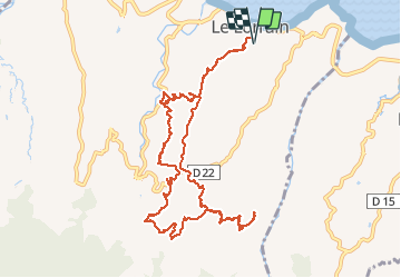

Length
18 km

Max alt
361 m

Uphill gradient
685 m
Km-Effort
27 km

Min alt
28 m

Downhill gradient
686 m
Boucle
Yes
Creation date :
2016-11-27 00:00:00.0
Updated on :
2016-11-27 00:00:00.0
5h53
Difficulty : Medium

FREE GPS app for hiking
 SityTrail
IGN / Geographical institutes
SityTrail Plus
The world is yours!
About
Trail Walking of 18 km to be discovered at Martinique, Unknown, Le Lorrain. This trail is proposed by Lamartiniere.
Description
moyenne
Positioning
Country:
France
Region :
Martinique
Department/Province :
Unknown
Municipality :
Le Lorrain
Location:
Unknown
Start:(Dec)
Start:(UTM)
709326 ; 1640451 (20P) N.
Comments